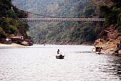
Piyain River
Appearance
| Piyain River | |
|---|---|
 | |
 | |
| Location | |
| Countries | India, Bangladesh |
| District | Sylhet |
| Physical characteristics | |
| Source | |
| • location | Umgat river of Assam |
| Mouth | |
• location | Surma River |
| Length | 145 kilometres (90 mi) |
Piyain River a trans-boundary river of India and Bangladesh.[1] It is a tributary of the Surma river, which is originates from the Umngot of Meghalaya. The river enters Bangladesh through Sylhet district.
The origin and flow
[edit]The length of the river is 145 km.[2] Piyain river has emerged from the river om or Umagat river or Assam.[3]
Gallery
[edit]-
Piyain River at Zero Point Jaflong
-
Piyain River at Chhatak Upazila
-
Piyain River. The picture was taken on the way to Bisnakandi
References
[edit]- ^ The story of a River of Jaflong in Bangladesh
- ^ Masud Hasan Chowdhury (2012), "Piyain River", in Sirajul Islam and Ahmed A. Jamal (ed.), Banglapedia: National Encyclopedia of Bangladesh (Second ed.), Asiatic Society of Bangladesh
- ^ Tourist Spot - Piyain River
External links
[edit]Wikimedia Commons has media related to Piyain River.


